Titterstone Clee Hill
Tue 27th Apr 2010: Ludlow to Titterstone Clee Hill and back
Distance: 15½m, Climb: 1830 ft
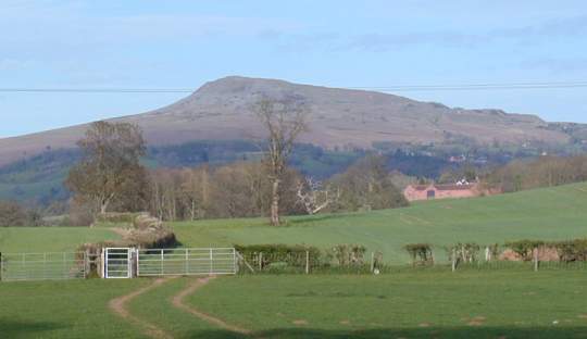
 It is impossible to visit Ludlow and not be aware of Titterstone Clee Hill just over 5 miles by the flying crow to the east. The photo right was taken from the castle walls on one of several earlier visits to the town, none of which had seen me striding out that way. Time to put that right. My whole walk was a little longer than necessary for a return visit, partly because I didn't want to use the same route each way, and partly because I decided for no great reason first to pass though town to Ludford Bridge rather than striking straight out for the hills from the station.
My outward path mostly followed the Shropshire Way as marked on the map OS203, though I didn't attempt to follow it through the housing estate towards Gallows Bank. Instead I stayed on the main road almost to its junction with the A49, turning left into the industrial estate to rejoin the Shropshire Way, the idea being to cross straight over the A road rather than having to follow it for a few hundred metres. The plan worked, though I did momentarily wonder whether I had taken the correct turning towards the A road as I found myself passing in front of the recycling plant. However just as I though I would be forced away from my desired direction a wooden post, itself out of place in this home of metal, pointed me in the right direction, and I soon found myself crossing the near empty A49, stepping over the crash barrier on the other side, and entering farmland.
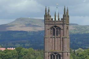
 Left: Looking back towards Ludlow from the vicinity of Knowbury.
The next four and a bit miles to the A4117 was mostly cross country, with just a couple of short sections of country road. Despite the occasional section of uneven ground most of the walking was good. Plenty of discs mark the way, so that often it is possible to spot exits from fields from the entrance. However as the map shows there are plenty of paths here, so the map was still needed to identify which path to follow in several places. Stiles rather than gates breach most of the boundaries, some may be difficult to negotiate for those with short legs. The fields are mostly put to arable use, though there were a few sheep, and in one small enclosure through which the path passed a couple of horses.
Reaching the A4117 I abandoned the Shropshire way, turning right to follow the road through Cleehill village to the viewing point at its eastern end, where I took time out to admire the view and enjoy a bar of chocolate. Said view featured one of my favourite walking areas - the Malvern Hills - as well as lesser lumps and bumps.
After a brief rest it was time to step on to Clee Hill. The first part passes a large active quarry in which large piles of graduated rock wait removal to their final destination. The open access land is mostly springy turf and heather, though there are several stone causeways sunk into the surface.
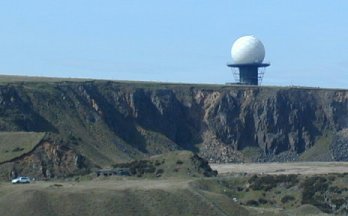 In due course the Earth Satellite Station comes into view above another (old) quarry. I wasn't looking to include a car in the picture, but it does serve to give a sense of scale. Is this the golf course of the gods, with quarries as bunkers? There are plenty around. "On the tee, Thor!". Cue thunder and lightening.
I take the long (anti-clockwise) route around the quarry station, coming at last to the triangulation point at the summit. There is a shelter immediately below the triangulation point, but I retrace a few footsteps and then descend into a hollow which is a more effective windbreak and offers more choice of seating points. Is this the Giant's Chair marked on the map? Perhaps not for elsewhere tis is described as a rocky and unconfortable seat. (The Shropshire Hills, David Walker, Cicerone) I found a perfectly comfortable place to picnic, though it does not take much imagination to believe the whole hollow to be formed by some giant's rearend whilst he rested with his legs dangling over the sharp drop towards the fields below. One thing is sure. This giant's chair is not simply the twin of the Devil's Chair from the Stiperstones.
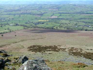 From my vantage point in the hollow I could view an arc from roughly north to roughly west, with the Long Mynd forming the backdrop to the north-west. Although I had never been here before I felt a wave of nostalgia, thinking back to the times as a teenager I had nestled in a similar hollow, then on a Dorset clifftop overlooking the sea. Here my 'sea' is a sea of fields stretching into the distace as effectively as the watery one of yore. My height is not immediately apparent from the picture. However although I didn't go down to check I'm fairly sure that the grey band of flecks towards the bottom of the pictiure are in fact stones of a similar size to those in the foreground.
Since leaving Ludlow I had met no-one other than in Cleehill village, and my solitude remained intact, a solitary figure I had spied from at least 400m when first approaching the summit quarry being nowhere to be seen. A low flying jet screamed past the peak, but as I was below the peak, I couldn't tell for sure whether it was too. A few minutes later a helicpter flying between Titterstone Clee Hill and Brown Clee Hill was definitely lower than the peaks. Its rotors flashed in the sunlight, turning it into a dragonfly.
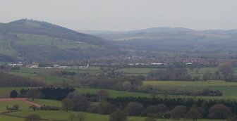
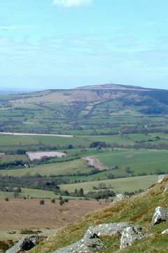 So at last I've visited Titterstone Clee Hill, but its slightly taller brother Brown Clee, pictured right from my hollow vantage point remains on the agenda.
Time now to return to Ludlow. Encouraged by the pavement I had found alongside the A4117 even before it entered Cleehill I resolved to take a dirct route towards Titterstone Farm, along the minor road towards Bitterley, but turning left at a crossroads to reach the beginning of a right of way leading past the Furlongs to reach the A4117 at Henley. This resolution proved not to be of the "New Year" type, for I had no temptation to break it. Returning to the triangulation point I started my descent almost directly down the hillside, initial deviations to avoid the steepest drops rapidly decreasing in regularity as I followed any sheep tracks or wheel tracks in the general direction of interest. Later, on leaving the road to take the track past the Furlongs I found it be as straight and easy to follow as the map implies, even though the final part passed through a number of fields, one of which was occupied by cows.
Pausing at Henley to take a last look back at the hill (picture below), I was then pleased to find that there is indeed a pavement all the way into Ludlow, saving me the need to walk on the admittedly lightly used road itself or find alternative paths. Thus my journey was for the main over, even though there were still a couple of miles to go to the station.
comment on this article